

You’re watching two figure skaters on ice, circling each other, getting closer with each rotation. Now imagine those skaters are massive hurricanes, each capable of devastating destruction, and their “dance floor” is the Atlantic Ocean just miles from the American coastline.
That’s exactly what’s unfolding right now, and meteorologists are calling it one of the most unpredictable scenarios they’ve faced this hurricane season.
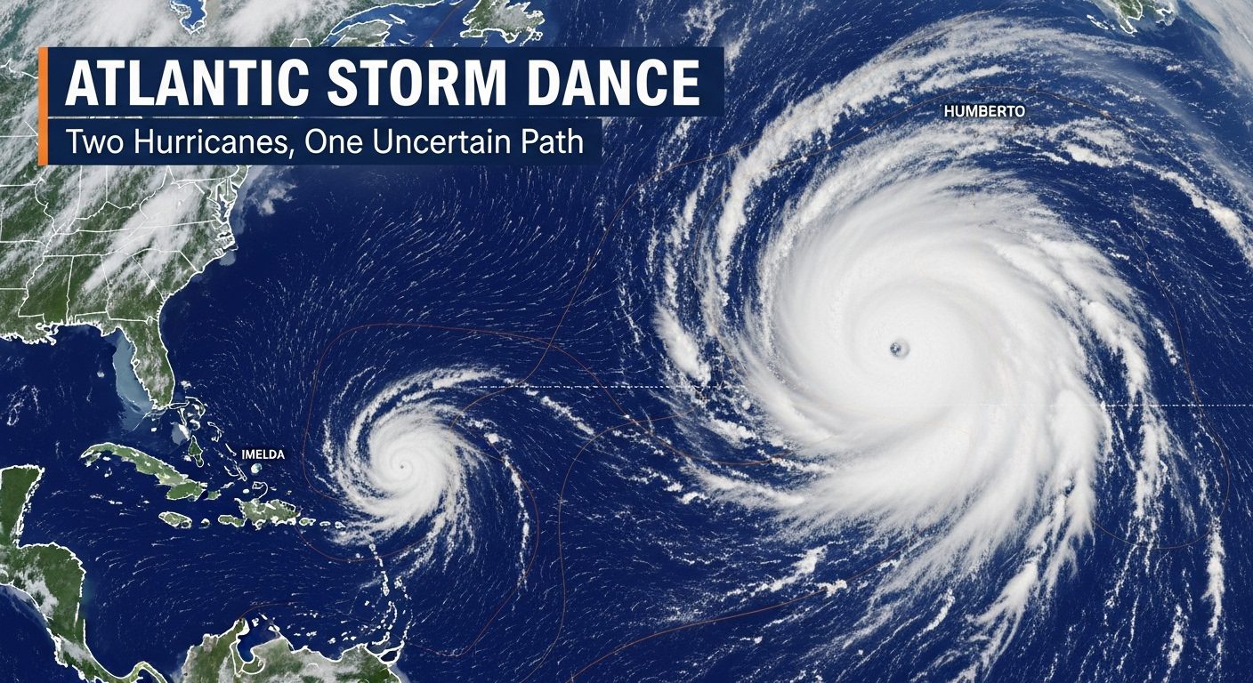
Tropical Storm Humberto is rapidly gaining strength east of the Caribbean, forecast to explode into a major Category 3 or 4 hurricane by this weekend. But Humberto isn’t the storm keeping weather forecasters up at night. It’s what’s brewing near Puerto Rico – a messy system that dumped torrential rain across the island Wednesday, claiming at least one life – that has everyone’s attention.
This developing storm, likely to be named Imelda within hours, is on a collision course with… well, that’s the problem. Nobody knows for certain.
In the world of hurricanes, there’s a phenomenon so rare and chaotic that even supercomputers struggle to predict its outcome. It’s called the Fujiwhara effect, named after the Japanese meteorologist who first described it in 1921. When two storms get close enough – typically within 900 miles – they begin rotating around each other like cosmic dance partners.
“If Humberto is stronger than the developing system, as seems likely, by late in the weekend Humberto could start to exert a pull east,” explains Dr. Ryan Truchelut, chief meteorologist at WeatherTiger. But here’s where it gets complicated: sometimes the larger storm absorbs the smaller one, creating a monster hurricane. Other times, they spin around each other before shooting off in completely different directions.
The last time Americans witnessed this atmospheric ballet was in 2017, when Hurricanes Hilary and Irwin performed their Pacific Ocean pas de deux. But having it happen this close to the U.S. coastline? That’s what has forecasters holding their breath.
For the 50 million people living along the Eastern Seaboard from Miami to Boston, this isn’t just a fascinating weather phenomenon – it’s a potential life-altering event. The developing storm near Puerto Rico is heading straight for the Bahamas, where it will feast on bathwater-warm ocean temperatures and likely strengthen into Hurricane Imelda.
From there, computer models paint two drastically different pictures. In one scenario, Imelda continues north and slams into the Southeast coast – most likely the Carolinas – as early as Monday. In the other, Humberto’s gravitational pull yanks Imelda eastward, sparing the coast but creating a merged super-storm in the open Atlantic.
The National Hurricane Center, typically confident in their 5-day forecasts, is hedging their bets. Their latest advisory includes an unusually wide cone of uncertainty, essentially telling millions of coastal residents: prepare for anything.
September in the Atlantic is always prime time for hurricanes. Ocean temperatures peak, wind shear drops, and storms can explode from tropical depressions to major hurricanes in just days. But 2025 has added a wild card: ocean temperatures that are running 2-3 degrees above normal, even for September.
That extra heat is rocket fuel for hurricanes. It’s why Gabrielle – now racing toward Europe as a post-tropical storm – strengthened from a Category 1 to a Category 5 in just 36 hours last week. It’s why Humberto is expected to undergo similar rapid intensification this weekend. And it’s why the developing system near Puerto Rico could surprise everyone.
“These aren’t your grandmother’s hurricanes,” says one Florida emergency manager who requested anonymity. “The rules have changed. Storms are strengthening faster, moving more erratically, and catching people off guard.”
While meteorologists debate computer models, real people are already suffering. In Puerto Rico, torrential rains from the developing system triggered flash floods and mudslides. One person died when their car was swept away by floodwaters – a grim reminder that tropical systems don’t need to be hurricanes to be deadly.
The Turks and Caicos Islands are next in line, with tropical storm warnings already posted. Hotels are boarding windows, tourists are scrambling for flights home, and locals are stocking up on supplies.
But it’s the uncertainty that’s perhaps most damaging. From Charleston to Cape Hatteras, coastal communities are stuck in limbo. Do they evacuate? Board up businesses? Cancel weekend plans? With the forecast changing every six hours, making decisions becomes nearly impossible.
The Fujiwhara effect isn’t just a curiosity – it can dramatically alter a hurricane’s impact. In 2012, Hurricane Sandy was influenced by a non-tropical system, creating the infamous “Frankenstorm” that devastated the Northeast. While not a true Fujiwhara interaction, it showed how storm interactions can create worst-case scenarios.
More recently, in the Pacific, when Tropical Storms Hilary and Irwin danced around each other in 2017, Irwin essentially got absorbed, its energy feeding into Hilary. If the same happens with Humberto and Imelda, the East Coast could dodge a bullet – or face an even stronger storm down the road.
The timing couldn’t be worse. Many communities are still recovering from previous storms. Building materials and protective structures like lean-to greenhouses that survived previous hurricanes are being tested again. Insurance claims are still being processed. And hurricane fatigue has set in, making it harder to convince people to prepare.
You might wonder: with all our satellites, computer models, and hurricane hunter aircraft, how can we not know where these storms are going? The answer lies in the chaotic nature of storm interactions.
Current weather models run thousands of simulations, each with slightly different starting conditions. Usually, these simulations cluster around a most-likely scenario. But when two storms interact, the simulations scatter like startled birds. A difference of just 50 miles in storm separation can completely change the outcome.
Hurricane hunters are flying into both systems, gathering crucial data. Their readings feed into models that are updated every six hours. But even with this real-time information, the Fujiwhara effect introduces a level of chaos that pushes our predictive capabilities to their limits.
If you live anywhere along the East Coast, from Florida to New England, this is your wake-up call. Not to panic, but to prepare. Emergency managers recommend having supplies for at least 72 hours without power or water. That means:
But beyond the physical preparations, there’s a mental component. Accept the uncertainty. Have multiple plans. Know your evacuation route, but also have a plan to shelter in place. Follow trusted sources like the National Hurricane Center, not social media speculation.
The next 48 hours will be critical. By Friday evening, Imelda should be a named storm, and its interaction with Humberto will begin in earnest. By Saturday, we’ll have a much clearer picture of whether the Carolinas need to brace for impact or breathe a sigh of relief.
But here’s what makes this situation unique: even if Imelda stays offshore, the combination of two major storms churning up the Atlantic will create life-threatening conditions along the entire East Coast. Waves up to 20 feet are possible. Rip currents will turn beaches into death traps. Coastal flooding could occur even under sunny skies.
“People think if the storm doesn’t make landfall, they’re safe,” warns the National Weather Service. “That’s not true. The ocean will be angry for days, regardless of where these storms go.”
While scientists are careful not to attribute any single storm to climate change, the pattern is unmistakable. Storms are intensifying more rapidly. Storm interactions are becoming more common. And the traditional hurricane season is expanding, with powerful storms forming earlier and later than historical norms.
The Fujiwhara effect itself isn’t necessarily more common, but the conditions that allow it – multiple strong storms in close proximity – are occurring more frequently. In a warmer world with more energy in the atmosphere, these spectacular and dangerous interactions may become the new normal.
As Thursday turns to Friday, millions of Americans will go to sleep not knowing if they’ll need to evacuate by Monday. Two storms are performing a dance of uncertainty in the Atlantic, and the music won’t stop until one leads and one follows – or they merge into something unprecedented.
Humberto will almost certainly become the season’s third major hurricane. The developing system will likely become Imelda within hours. What happens when they meet is anyone’s guess, but one thing is certain: the Atlantic hurricane season of 2025 just got a lot more interesting – and dangerous.
Stay tuned, stay prepared, and remember: in the age of rapid intensification and storm interactions, the only predictable thing about hurricanes is their unpredictability.